Parts of Accra were shaken by a fleeting earth tremor Wednesday night which threw residents into fear and panic.
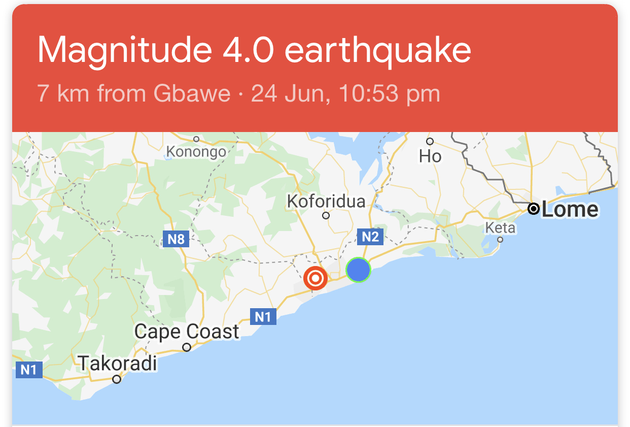
According to the USGS (United States Geological Survey), it recorded a magnitude of 4.0 with a 10.0-kilometre depth at 10: 53 pm and occurred at 6 km from Gbawe in Accra.
READ ALSO: Earthquake measured 4.2 on the Richter scale - Ghana Geological Survey Authority
It was felt three times in the space of 10 minutes and shook buildings, creating panic among residents.
Many residents reported on social media that they felt the earth shaking on Wednesday night, June 24, 2020.
Some of the areas the tremor was felt in Ghana as monitored by Graphic Online on social media included Gbawe, McCarthy Hill, Kaneshie, Tesano, Dansoman, Dunkanaa, Lapaz, Achimota, Santa Maria, Adenta, Weija, Madina, Kwabenya, East Legon, Nsawam, Koforidua, Swedru, Dodowa, Tema among others.
In Adabraka and Nima, there were reports of people running out of their homes to seek refuge in open spaces.

What a CCTV in someone's house captured on Wednesday night in the Ghana tremor.
World Map showing incidents of earthquakes on June 24, 2020

ABOVE - World map showing earthquakes above magnitude 3 in the past 24 hours on June 24, 2020.
The Earthquake report worldwide on Wednesday, June 24 showed incidents in various parts of the world.
Summary: 289 quakes Magnitude 2+, 98 quakes Magnitude 3+, 54 quakes Magnitude 4+, 7 quakes Magnitude 5+.
The total was 448 quakes.
There were no quakes measuring Magnitude 6+ to Magnitude 9+ within the period.
The 10 largest earthquakes in the world recorded in the period were:
#1: M 5.9 quake: Near East Coast of Honshu, Japan on Wed, 24 Jun 19h47
#2: M 5.9 quake: New Zealand on Wed, 24 Jun 22h20
#3: M 5.8 quake: 18km SSE of Lone Pine, CA (USA) on Wed, 24 Jun 17h40
#4: M 5.4 quake: Near Coast of Oaxaca, Mexico on Wed, 24 Jun 02h33
#5: M 5.3 quake: New Zealand on Wed, 24 Jun 02h02
#6: M 5.1 quake: New Zealand on Wed, 24 Jun 06h41
#7: M 5.1 quake: Ecuador on Wed, 24 Jun 15h38
#8: M 4.9 quake: Myanmar-India Border Region on Wed, 24 Jun 19h44
#9: M 4.9 quake: South Sandwich Islands region on Wed, 24 Jun 23h12
#10: M 4.8 quake: 36 km al SUROESTE de S PEDRO POCHUTLA, OAX (Mexico) on Wed, 24 Jun 20h06

Warning in Ghana
Already, the Ghana Geological Survey Authority (GGSA) has warned that the series of tremor occurrences in parts of the Greater Accra Region over the years is signal of a looming earthquake of greater magnitude in the future.
On March 24, 2018, a similar earth tremor that measured 4.0 on the Richter scale was recorded in Accra.
On December 9, 2018, another one was experienced in Accra.
- Related articles:
- Geological Survey warns of looming earthquake in Accra
- Earth tremor hits Weija, Gbawe environs
The Richter scale is a scale of numbers used to tell the size of earthquakes. Charles Richter developed the Richter Scale in 1935.
If the scale is less than 2.0, it means that the earthquakes are very small and are unlikely to be felt by people.
Between 2.0 and 2.9 on the scale, people do not feel the earthquakes, seismographs are able to detect them.
Beyond 5.9 on the scale, earthquakes can cause serious damage to lives and property over large areas.
Ghana is said to have a major earthquake fault line stretching from the McCarthy Hill area in Accra westwards towards the Central Region and eastwards towards the Akuapim Ridge all the way to the Volta Region.
The epicentre of the fault line is thought to be located around the McCarthy-Weija Dam catchment area.
Since 1615 and 1939 when Ghana experienced its severest earthquake with a magnitude of over 6.0 on the Richter scale, there have been reported yearly occurrences of fleeting earth tremors.
According to the GGSA, signs picked up after earth tremors hit parts of Accra on March 24, 2018, showed that the fault lines were active, which meant that an earthquake could occur at any time.
The fast-sprawling town of Kasoa in the Central Region and Gbawe in the Greater Accra Region have shared the most spoils in occurrence.
The most recent, with a 5.9 magnitude and a 33-kilometre depth, occurred at 3 p.m. on September 26, 2007, with a depth of 385.2 kilometres from Takoradi, while 23 years ago at 3:16 p.m. on March 6, 1997, another one measuring 4.4 in magnitude and with a depth of 10 kilometres occurred 6.2 kilometres from Gbawe.
Gbawe was in the news again 30 years ago with two earthquake experiences. The first, measuring 3.1 in magnitude and 10 kilometres in depth, occurred at 11:43 a.m. on April 14, 1990, with a depth of 4.2 kilometres from the town, while the second, which measured 2.7 in magnitude and 10 kilometres in depth, occurred at 1:34 a.m. on February 12, 1990, 1.2 kilometres from the community.
In the last 33 years, Kasoa has also had its fair share of earthquakes — there was one measuring 2.0 in magnitude on March 23, 1989; 3.4 on February 27, 1988 and 3.1 on December 3, 1987, all 10 kilometres in depth.
Other occurrences
In 2014, a similar situation was reported, which caused the Chief Executive Officer of Development Geo-Information Service (DeGEOSERV), at the time Prof. Emmanuel Amamoo-Otchere, to caution residents of the affected areas to either relocate or take steps to protect their buildings against earth tremors.
On January 12, 2006, a tremor measuring 3.7 on the Richter scale hit parts of the capital, according to the Geological Survey Department.
There was a similar tremor — measuring 3.8 on the Richter scale — in May 2003.
Suburbs of the capital, such as Dansoman, Weija, Ashale Botwe, Madina, East Legon, La Trade Fair and Sakumono and their adjoining communities all felt the earth movement.
Legislation
Parliament, in 2016, passed legislation to empower the demolition of a number of houses and other structures along the Accra-Cape Coast main road that are close to earthquake fault lines.
The legislation, the Ghana Geological Survey Authority Act, seeks to reduce the impact of disasters related to earthquakes, volcanic and other seismic activities throughout the country.
It established the Ghana Geological Survey Authority, with the mandate to advise the government on geo-scientific issues relating to mineral resources, the environment and hydro-geology.
It will also promote effective dissemination of information on geological hazards and ensure the effective exploration and exploitation of mineral resources in the country to ensure standards of professional conduct and efficiency in geological matters.
Below are some reactions on social media
Who experienced the earth tremor at 10:50pm.
— Saddick Adams (@SaddickAdams) June 24, 2020
Really shook our building like bad
Yoo is anyone else experiencing the earth tremor or it’s just at my place cos adey shake 😂
— Kelewele Joint 🍟 (@Ankamagyimi) June 24, 2020
The thing has happened twice ei.
Who felt that earth tremor? Sparked 3 times.
— mutombo🤯 (@MutomboDaPoet) June 24, 2020
Earth Tremor three times in few minutes. Hmmm. Who else experienced it? #earthTremor
— Ewura Abedu-Kennedy (@KendraAbedu) June 24, 2020
I’m at McCarthy hills and this earth tremor scaring me. It’s happening right now as I’m typing. #earthtremor
— Apartment Therapy (@apt_therapy) June 24, 2020
Third Earth Tremor in Accra under 15 minutes.
— Dominick 💢 (@nickhotor) June 24, 2020
That fault line from McCarthy Hill through to the Accra Central where there was a major earthquake in 1939 must be shifting.#Ghana #Accra #earthtremor
Please who is experiencing the earthquake in north Kaneshie
— Bernard Ampofo Amponsah (@B_bernard13) June 24, 2020
more to follow...
Writer's email: