Flooding has emerged as one of the most pressing environmental and urban development challenges confronting Ghana today.
In major urban centres such as Accra, Kumasi, Takoradi, Tema, Kasoa, and several rapidly expanding municipalities, floods continue to claim lives and destroy homes and businesses.
The floods also damage public infrastructure and impose high economic costs on both the government and citizens.
Although climate change and increasingly unpredictable rainfall patterns have intensified flood risks, experts argue that a substantial portion of Ghana’s flooding problem is man-made.
Central to this concern are persistent violations of planning regulations, weak development control systems, and the widespread encroachment on wetlands, floodplains, waterways, and natural drainage channels.
As flood disasters become more frequent, questions are increasingly being asked about the effectiveness of planning authorities, local assemblies, regulatory agencies, developers, and landowners in protecting critical environmental assets that serve as natural flood defences.
Wetlands
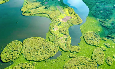
Wetlands are among the most valuable natural ecosystems in the world and play a crucial role in flood management.
These include marshes, swamps, lagoons, floodplains, estuaries, and low-lying waterlogged areas that naturally absorb, store, and gradually release excess water during periods of heavy rainfall.
Environmental experts describe wetlands as natural sponges because of their ability to retain large volumes of stormwater that would otherwise inundate nearby communities.
According to the Ramsar Convention on Wetlands, wetlands provide numerous ecological and environmental benefits, including: Flood attenuation and stormwater storage, groundwater recharge and replenishment, natural filtration and purification of water and protection of biodiversity and wildlife habitats.
Climate regulation
Ghana is a signatory to the Ramsar Convention and has designated several wetlands as internationally protected sites.
These include the Sakumo Ramsar Site, Densu Delta, Muni-Pomadze, Keta Lagoon Complex, and Songor Lagoon wetlands.
However, despite their ecological significance, many of these wetlands continue to face increasing pressure from urban development, land reclamation activities, and illegal construction.
Environmental scientists warn that when wetlands are destroyed, filled with sand, or converted into residential and commercial developments, communities lose a critical natural defence mechanism against flooding.
Over the past three decades, Ghana has experienced rapid urban growth driven by population increases, rural-urban migration, and rising demand for housing and commercial infrastructure.
While urban expansion has contributed to economic development, it has also placed immense pressure on environmentally sensitive areas.
In many parts of Greater Accra, Ashanti, Central, Western, and Eastern regions, wetlands and flood retention areas have increasingly been transformed into residential estates, shopping centres, industrial facilities, roads, transportation infrastructure and informal settlements.
Areas such as Weija, Adentan, East Legon, Ashaiman, Kasoa, Kumasi, and sections of Tema have witnessed significant development within flood-prone zones and natural drainage corridors.
The consequences become evident whenever heavy rainfall occurs, and water that would ordinarily be absorbed by wetlands is instead forced into surrounding communities.
Natural drainage pathways become blocked, stormwater accumulates rapidly, and drainage systems become overwhelmed.
As a result, floodwaters rise faster, and flooding becomes more severe.
Recovery becomes more expensive, and vulnerable communities face greater risks.
The Water Resources Commission (WRC) and the Environmental Protection Agency (EPA) have repeatedly identified uncontrolled development in wetlands as a major contributor to urban flooding across Ghana.
Legal framework
Ghana possesses a comprehensive legal and institutional framework designed to regulate physical development and protect environmentally sensitive areas. Several key laws provide the foundation for planning and environmental management.
Land Use and Spatial Planning Act, 2016 (Act 925). This legislation serves as the primary legal framework governing spatial planning and development control in Ghana.
The Act requires all developments to conform to approved planning schemes and empowers planning authorities to: regulate physical development, prevent unauthorised construction, protect environmentally sensitive areas, and enforce planning standards and regulations.
The law also emphasises orderly development and sustainable land-use practices aimed at reducing environmental risks.
Under this Act, Metropolitan, Municipal, and District Assemblies (MMDAs) are responsible for granting development permits and ensuring compliance with approved planning regulations.
Assemblies are expected to conduct technical assessments and monitor developments within their jurisdictions.
The Environmental Protection Agency is mandated to oversee environmental management and ensure that projects likely to have significant environmental impacts undergo appropriate environmental assessments before implementation.
Building flood-resilient cities
Urban planning experts have proposed several measures to strengthen Ghana’s resilience to flooding.
One of these measures is strict enforcement of development controls: Regulations must be enforced consistently, regardless of political, social, or economic pressures.
There is also the need to protect wetlands and buffer zones. Wetlands should be recognised and preserved as essential infrastructure for flood management.
Development applications should incorporate hydrological studies, environmental impact assessments, and flood-risk evaluations. Geographic Information Systems (GIS), drones, and satellite imagery can help identify and monitor encroachments more effectively.
Citizens must understand that wetlands are critical environmental assets rather than unused land available for development.
Greater coordination among planning, environmental, water management, and disaster response agencies is essential for effective flood prevention.
Conclusion
Flooding in Ghana is not solely the result of heavy rainfall or climate change.
It is also a reflection of planning decisions, regulatory compliance, institutional effectiveness, and society’s commitment to sustainable development.
The continued encroachment on wetlands, floodplains, and natural drainage systems—whether through unauthorised construction or weaknesses in permit administration—has significantly increased the vulnerability of urban communities.
Wetlands serve as natural infrastructure that protects lives, property, businesses, and public investments.
Their destruction often generates costs that far outweigh the short-term benefits of development.
As Ghana continues to urbanise, sustainable growth will depend on the willingness of planning authorities, developers, policymakers, traditional authorities, landowners, and citizens to uphold environmental regulations and protect critical ecosystems.
Stronger enforcement, improved accountability, and more effective land-use planning will be essential if the country is to reduce flood risks and build safer, more resilient communities for future generations.
The writer is the Chief Executive Officer of Lakeside Estate and a development practitioner